Autumn 2009 storms
From February to June 2009, the Tweed-Byron and Gold Coast beaches experienced the stormiest period in more than 20 years. seven significant ocean storms hit these coasts, each with a maximum significant wave height of more than 3 m. (Significant wave height refers to the average height of the top 1/3 of waves occurring)
Beaches most directly linked to TRESBP operations (Letitia Spit Beach, Duranbah Beach, Rainbow Bay, Greenmount Beach, Coolangatta Beach and Kirra Beach) were amongst the many beaches impacted by the storms.
The most severe of the storms occurred from 19-25 May 2009, causing extensive costal erosion and flooding along the entire Tweed-Byron and Gold coasts.
The May 2009 storm was an East Coast Low Pressure System and arrived at the coast from just north of east. A maximum significant wave height of 5.6 m was recorded on 21 May 2009 and significant wave heights remained above 4 m for 4 days. This makes it the longest duration severe storm recorded by the TRESBP, that is, the worst protracted storm in at least 14 years for the east facing beaches which were fully exposed to the storm waves.
See graph of Autumn 2009 Tweed Buoy wave heights compared to median wave heights and average storm wave heights.
Access the Queensland Department of Environment, Science and Innovation links to data recorded by the Tweed Heads buoy and the Tweed Offshore buoy.
Prior to the May 2009 storm, five other storms occurred in close succession:
- 14-15 February 2009 (Hsig=3.12 m)
- 11-12 March 2009 (Hsig=3.7 m)
- 30-31 March 2009 (Hsig=4.1 m)
- 1-6 April 2009 (Hsig=4.6 m)
- 19-22 April 2009 (Hsig=3.2 m)
The longest period of non-stormy weather between two storms over this period was about 4 weeks. The intervals between the storms were not long enough for natural beach recovery to occur to any significant degree, and therefore beaches along the Tweed-Byron and Gold coasts were already in a fairly eroded state when the May 2009 storm hit.
The May 2009 storm also coincided with larger than average (spring) tides. The large tides enabled storm waves to penetrate further into dunes and foreshore areas during the daily peak mid and high tides, extending the zones of erosion and damage.
The combined effects of huge waves, coastal flooding, spring tides and pre-eroded conditions of the beaches during the May 2009 storm led to the worst erosion seen on the Tweed-Byron and Gold coasts in many years, including some significant changes to beaches closest to TRESBP operation from Letitia Spit to Kirra Beach. Some examples are listed below:
At Belongil Beach at Byron Bay, private beach front properties were undermined and homes were threatened.

(Photograph by David Clark, courtesy of The Gold Coast Bulletin)
Between Kingscilff and Fingal Head, erosion scarps of up to 3 m were carved by storm waves and many pandanus trees were lost from dunes.
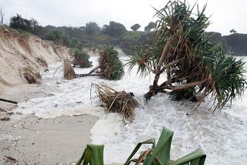
(Photograph by Brad Wagner, courtesy of The Gold Coast Bulletin)
Along Letitia Spit many sheoak and banksia tress were lost from dunes and a large dredge float thought to be from the 1970s or earlier was uncovered on the beach.

(Photograph by Qld DERM)
At Duranbah Beach, boulders and a board-and-chain pedestrian walkway that had not been seen in many years were uncovered at the north end.

(Photograph by Mike Batterham, courtesy of The Gold Coast Bulletin)
At Snapper Rocks and Rainbow Bay, a scarp of up to 1 m was carved by storm waves and access steps were undermined.

(Photograph by Brad Wagner, courtesy of The Gold Coast Bulletin)
Offshore at Rainbow Bay, surfing banks were flattened out by the huge swell. At Snapper Rocks, a depression of up 2.5-4.5 m deep formed in the seabed in the surfing take-off zone.

(Photograph by Mike Batterham, courtesy of The Gold Coast Bulletin)
At Greenmount Beach, the shoreline retreated to the narrowest condition seen since prior to 2002.

(Photograph by NSW LPMA)
At Coolangatta, storm waves penetrated into the dune regeneration area near Kirra Point groyne.

(Photograph by UNSW
WRL)
At Kirra Point, rocks that hadn't been seen since prior to 2001 were exposed by storm waves.
(Photograph by NSW LPMA)
At Kirra Beach, a scarp of up to 1 m was carved across the beach and the shoreline retreated by about 50 m.

(Photograph by NSW LPMA)
Offshore in the Kirra zone, more than 200,000 m3 of sand was shunted to the north by storm swells, uncovering parts of Kirra Reef that have not been seen in recent years.

(Photograph by QLD DERM)
At Tugun Beach, scarps of up to 2 m were carved by storm waves in the vicinity of the surf life saving tower, and large debris had to be removed from the beach by heavy machinery.

(Photograph by Scott Fletcher, courtesy of The Gold Coast Bulletin)
At Currumbin, a car was washed from the surf club car park down into the surf by storm waves, and dune fencing was destroyed.

(Photograph by David Clark, courtesy of The Gold Coast Bulletin)
At Palm Beach, severe beach erosion occurred, private beach front properties were undermined and homes were threatened.
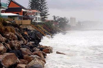
(Photograph by Brendan Radke, courtesy of The Gold Coast Bulletin)
